How To Use the AllTrails App (For Beginners)
How To Use the AllTrails App (For Beginners)
 Learn how to find, save, and navigate hikes with the AllTrails app—even offline—using this simple beginner’s walkthrough.
*AllTrails Discount Code:*
https://alltrails.pxf.io/c/5076976/2933040/22353
*Gear I’m Using Now:*
* inReach: https://hkgy.co/inreach
* Hiking App: https://hkgy.co/app
* Watch: https://hkgy.co/watch
* Shoes: https://hkgy.co/shoes
* Pack: https://hkgy.co/backpack
* Rescue Insurance: https://hkgy.co/insurance
*Full Hiking Gear List (What I Use Now – Tested & Not Sponsored):*
https://hikingguy.com/gear
*Links:*
* Website: https://hikingguy.com
* Patreon: https://www.patreon.com/c/hikingguy
* Monthly Hiking News (free): https://www.patreon.com/c/hikingguy/
* Subscribe: https://www.youtube.com/c/Hikingguy
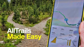
If you’re new to the AllTrails app, this beginner’s guide will walk you through everything you need to know to start finding and navigating hikes with confidence. I’ll show you step-by-step how to explore trails near you, filter your search, read recent reviews, and check trail details like closures, permits, and elevation profiles before you head out.
We’ll go over how to use the interactive map, view routes in 3D, and save your favorite hikes so they’re easy to access later. I’ll also cover the AllTrails Pro features—most importantly, how to download offline maps so you can navigate without cell service. That means you’ll still be able to follow the trail line, see your location, and stay on route even in remote areas.
You’ll learn how to start recording your hike, use the red trail line to stay on track, and check your progress at trail junctions. I’ll share tips for saving phone battery on the trail, like using airplane mode, turning off the screen when you’re not checking the map, and carrying a small USB battery pack as backup.
Finally, I’ll explain how to finish and save your hike in the app so you can track your completed trails and add photos or notes for future reference. Whether you’re just getting started with hiking or looking for a simple navigation backup, the AllTrails app can be a great tool—especially if you understand how to use it before you hit the trail.
—
*Disclaimer:*
Some of these links are affiliate links where I’ll earn a small commission if you make a purchase at no additional cost to you. I only recommend gear I actually use and trust.
This was a great intro, but it would be helpful now for you to compare AllTrails to Trailforks. I’ve used some of their stuff useful, but prefer Trailforks, which works well with/on Garmin, and Gaia. I’d be interested in your comparison.
Thank you, great video
Can you down load as a gpx file ?
In my opinion, AllTrails is useless! Unless it can show the adjoining trails, it’s easy to get lost and for anyone who says to just zoom in, well that doesn’t work.
Turn-by-turn?
Perfect explanation, thank you. Quick question – the phone is not switching off and screen is fallowing your location ony in the payed version, correct?
I had the issue, even I downloaded the apps and I had no phone signal When I was navigating, After 1 minutes I see a no connection error and the app would freeze. When I restart the app, it resumes normal and again same happens. Anyone had this issue?
Great tutorial. I am a beginner and this is really helpful. Thank you.
I was surprised that offline (no service) the downloaded map was still able to locate my position, this was very handy during a tough hike to let me know how much progress I was making and then estimate my arrival time (hopefully before dark 😂) impressed at the simplicity and functionality 😎🤙
Thanks for the primer.
Is AllTrails only for existing hikes? On Catalina Island, I’d like to hike from Little Harbor to Ben Weston Beach. I’ve been told it’s hard to find your way there without a map. It seems like Google Maps will help me do that, but I can’t figure out a way to do this not currently listed hike through AllTrails. Many people seem to have cell service all over Catalina Island, but my T-Mobile service only works in Avalon or right in Two Harbors Village. So anything that needs service won’t work from Little Harbor to Ben Weston Beach. Thank you as always for the useful info!
Hi Hiking guy, I’m a new subscriber, love your video. I left a similar comment in another video, would you say garmin Epix is as good as Alltrails for following a hiking trail? I like how Alltrails has reviews of trails, does garmin also have this?
I am looking for the best app or software for researching and planning a backpacking trip that connects multiple trails. AllTrails is great for published single trails.
The best method so far is the tried and true paper map. Any suggestions?
thanks for the demo!
Thanks for the great video on AllTrails! I found it while reviewing your video on hiking cactus to clouds. I’m considering doing it in late May and using the AllTrails app pro feature. When you’re using a downloaded map, and you are off-line in airplane mode, will it alert you if you go off route? My concern with the cactus to clouds route is following it and staying on the trail starting early in the morning in the dark.
New to hiking so this is a helpful video. One thing that I am interested in is finding the waterfalls in my State. What I have noticed that there isn’t a marked road to these and some of the waterfall sites will list coordinates that you have to plug into AllTrails. Not sure how to do that.
Thank you so much !!!!
Does it show you how to get back to your starting point?
Does this offer bike trails?
All the trail apps lost me at subscription for out of date maps.
What watch works best with AllTrails free app?
This is Freaking Awesome!!! Can’t wait for my very large dog and I can get started!!! As soon as I can buy my truck!!! 🚛
I just got the pro version and haven’t used it yet but this video speaks volumes. I also have a garmin mini 2 gps, but I think the navigation isn’t nearly as good. Question I have for the downloaded trails/ maps for Alltrails app; if you do an out and back trail that involve some areas that aren’t clearly marked , is there a feature to track back to your start point using a bread crumb trail?
So when you say turn off the phone. Do you mean to power it off or just close out the phone app and put the phone in standby
Thanks. I’m thinking of giving Alltrails a try for my next ridiculously undocumented trail I go on. -just an extra level of helpfulness.
"It’s not a lot of money, it’s just like a subscription…" xD
Have tried Gaia and can’t get the curser/me on my dirtbike, to move while i’m moving/riding same as Google/maps/GPS does.Have to stop every 10 minutes to re-centre.Can i do this on Alltrails.
Great video! Thanks!
Can you make a video teaching us how to use the ALL TRAILS APP now with the updated version of it? To get the best out of it, either with the free version and the pro account.
If you use an Apple Watch for hiking what would be your to go app for offline maps to use on your watch?
Does AllTrail Pro allow re-routing? I often get off the original trail path and take a different trail path. I haven’t find a way to re-route my way back to trailhead or select or custom a path back to my destination from the app.
is the a voice navigation option?
HI GOOD MORNING !
THANK YOU 🙏 I’VE HAD MINE FOR A WHILE JUST HAVEN’T USING IT / THEM . OR GETTING OUT AS OFTEN AS BEFORE . I’M GOING TO START WATCHING 👀 YOUR VIDEOS 📹 MORE & GET MYSELF OUT MORE . I JUST PAYED FOR THE ALLTRAILS APP TO START DOING THE HIKER / BIKER TRAILS 👣 AROUND MY AREA MAINLY BIKING GETTING MY GRANDSON OUT OF THE HOUSE 🏠, ME TOO . BE SAFE ! HAVE FUN ! ENJOYED 🍨 🍨 🍨 🍨 🍨 🍨 🍨 🍨 🍨 🍨 GOD BLESS YOU ALWAYS ON YOUR ADVENTURES 🙏 THANK YOU FOR TEACHING / SHOWING ME / US HOW TO USE WHICH EVER ONE WE HAVE .
Great job explaining and capturing the real time application experience.
so i love the app its amazing, but i hate with a passion how annoying it is to get my hpone out my pcoket unlock, phone, put in pin n swipe to view the app each time, on new routes im doing this like every 5 mins. has anyone used a wrist/arm strap to get away from the annoying issue of getting your pone out and having to unlock? – i just realised my phone can do face unlock which helps the process. still annoying taking it ou pocket or holding in hand all the time. so just need a wrist wrap if anyone ever used them?
They usually have a discount around Black Friday 👍🏻🌵
Is there a wrong turn alert please
Just remember to turn off your recording before you get home, otherwise you’ll let the world know where your bedroom is, lol.
Awesome overview, I loved how you had the close up of the app on the side while you were showing us how you were navigating. I just bought the pro version based off your vid. I’m notorious for getting lost, both when adventuring in cities and on trails, so the offline maps are going to be a massive help. Well, hopefully, maybe I’m beyond help…
Happy hiking!
Hey Hiking Guy…… I have a question…… can you answer it ?……what happens when you do this on a Forerunner 255 ??? …… will you get a background map ??? ……. also it is quite UNCLEAR if a GPX file actually contains the background map image or merely the course POINTS ?? …. fenix model comes with built-in USA topomaps and I suspect that course merely appears on top of that …… for all Garmin models that come with NO maps, I suspect you will get the course but NO background map at all ….. can you comment on this ? …… I have a vested interest in KNOWING for certain as (unfortunately) I believe the model I ordered (but have not yet received) does NOT support maps
I was looking at several of the GPS apps and decided on AllTrails mainly because the hikes I’m planning will be on established trails and they seem to be on the AllTrails app. No importing maps needed. It seemed easier for a weekend warrior than some of the other apps.
Really enjoying your six pack challenge in San Diego. I’m primarily a cyclist, but would enjoy keeping with the long Saturday hikes. Do you have a top 20/30 list of San Diego hikes? I’m targeting 4+ hours/8 to 10 miles?
Much appreciated
If I travel with a group like my family how to make sure everyone gets the same route? does everyone have to get the full version of the app?
This was an EXCELLENT tutorial and demo! Thank you!
Do yo uknow if AllTrails app has direction to The Wave and in particular to the San Cove, Melody Arch and Top Rock Arch?
How come my download isn’t working if I have no signal or data, I know this should work still since it’s downloaded already
when the map is downloaded for offline use the the arrow showing where you are still work?
Hi. I have been following you for some years now, and your are really one of best and I really enjoy your videos. I’m not a the best hiker, I do mostly short hikes, 3-6 km. but I would like to have a god HikingApp. Two years ago I tried the Gaia GPS, but I didn’t feel it was the right for me. I don’t know if you can answer this question, but is the app AllTrails a better and easier app for me? Im going to Portugal and will hike a lot, they should have some fantastic hikes. I’m not a young guy, 70😒, but in god shape. Hope you can answer this question. Thanks for all your videos.
Thank you for your great videos. Just bought a Garmin 66sr after reviewing information on your webpage. I also bought AllTrails+ and would like to upload trails to my Garmin 66sr. When I save and upload a GPX file to the Garmin Connect app it ends up in "courses" in the "training and planning" menu. When I select "send to device" I receive the message "your device does not support courses". Any videos/recommendations how to best upload an AllTrails file/gpx to a Garmin 66sr via a Garmin phone app?
what did you press to open it up in apple maps? (3:06 on your video)
Thanks for the video, informative as usual. I tried AllTrails as a way of downloading a GPX to Garmin Explore and then send it to my 66i. Works fairly well and saves time. Unfortunately I can’t get it to be a route with turn by turn and approach signals. It was only a track to follow. Still, it’s a good backup. I still like to use map and compass which AllTrails allows for, by downloading PDF maps.
My All Trails app doesn’t look anything like that!